

16-month investigation and $500,000?
Heck, just follow my red line, and add some houses while you’re at it!
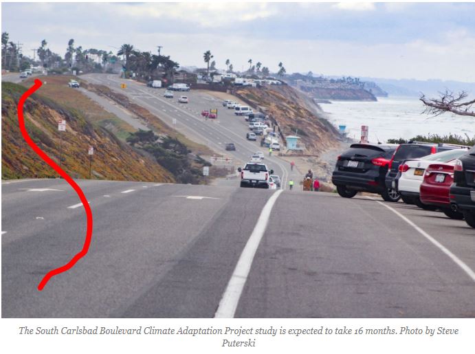
CARLSBAD — The city is preparing for sea-level rise by partnering with a prominent local research organization to perform a realignment study on a portion of Carlsbad Boulevard to help mitigate any future structural damage due to climate change.
The South Carlsbad Boulevard Climate Adaptation Project marks the first major review of the city’s infrastructure in relation to sea-level rise, according to Mike Grim, the city’s senior program manager.
The study is expected to take about 16 months and return to the council in Feb. 2023, according to Grim.
“It’s doing a little more detailed analysis of bluff erosion and flooding impacts would be due to sea-level rise or extreme storms,” Grim said. “And then analyzing the realignment of the boulevard and then what to do with that intervening space. We are going to move that as far east as we can.”
The Carlsbad City Council approved a $498,075 grant during its Sept. 14 meeting from the California State Coastal Conservancy for Scripps Institute of Oceanography to conduct studies on sea-level rise and how to move the road’s southbound lane eastward, away from the ocean, between Palomar Airport Road and Island Way.
The city will begin its public outreach to residents and businesses in January.
Fields said one deliverable is for a 30% engineering design for the roadway realignment with the southbound lane (closest to the coast) moving inland.
“It will be an inland migration of the southbound lane into a combination with the northbound lane and a footprint with the northbound lane,” Fields said. “It does have a lot of complex components within the project because it is this whole revisioning of this one-mile section of the coast.”
Adam Young, a project scientist with Scripps, said there are two goals for his portion of the project, analysis of historical data to assess coastal erosion and modeling of a future coastline.
Young said the erosion projections are currently underway and expected to be completed sometime next year. The project team will use a variety of models to form a consensus on predictions regarding how high sea-level rise may be and what impacts erosion may have west of Carlsbad Boulevard, also known as Coast Highway.
“We’re assessing the rates of erosion so they can design properly so the roadway is far enough back, so it won’t be threatened by erosion in the future,” he added. “I do think using a variety type of models help form the confidence in the outcome.”
The study will also other potential land uses, such as a 62-acre park with an open space the council discussed during its Oct. 12 meeting as part of the Local Coastal Program update.
https://thecoastnews.com/scripps-to-conduct-realignment-study-of-carlsbad-boulevard/


Here. Where’s my $500k?
https://dot.ca.gov/caltrans-near-me/district-11/programs/district-11-environmental/i-5pwp-toc/appd
Of course those are “projections.”
The straight line truth:
https://www.researchgate.net/figure/Observed-monthly-mean-sea-level-cm-from-Seattle-San-Francisco-San-Diego-tide-gauges_fig1_225757510
If you want to have a fun adventure, find these markers:
https://tidesandcurrents.noaa.gov/benchmarks/benchmarks_old/9410230.html
but JtR, Carlsbad Police will no longer have a safe place to check the surf…..errrrr, I mean…..setup their speed traps.
/s
Just add a few more large boulders along the shore down at the bottom of the dip as was done a few years back and we are good until 2100. At king tide/high tide last week of 8’+ there was no water what so ever getting close to the roadway.
Just don’t let the brainiacs from the city of SD anywhere near it. You’ll end up with a single lane for cars, bike lanes that no one uses, parking spots in the middle of the road, and all for about 20 gobzillion dollars per mile in the name of fighting rising sea levels. Uh huh. Or, just leave it as is and come back in 20 years and discover it’s almost exactly as it is now and that we all didn’t die from giant tsunamis.